Date: 14th November 2021
2017 version below
 Welcome to the Canadian Rockies, home of an epically long ice season, epic amounts of ice climbing, expensive beer and stoked people! I often get asked for information about climbing here, so I’ve written a few documents that I hope will help both new and visiting climbers have a good trip. For a general understanding of our season and ranges, check out this link. We reliably have ice from mid-October to early May or later. If you’ve read the “ice season” link then you kind of know the basics of what forms first and melts last, etc. There’s also a page on “Canmore Resources” with places to stay, eat, drink, etc. I’m not paid on any of those recommendations. Big Picture: When I go to a new rock climbing area I often have a list of routes I want to do, and then adapt that a little based on the weather and crowds etc for each day. Winter climbing in the Canadian Rockies doesn’t work that way. The Rockies tell us what we can and can’t do, and then we figure out how to fit our climbing into current avalanche and ice conditions. Many visiting/new climbers show up here with a list of dream routes without looking at the current conditions, and some don’t survive. The following is my workflow for deciding what to climb whether it’s a personal mission or getting my guests the best possible day. I look at this info every night starting in mid- October, and often in the morning before going. I’m doing a video of all the info below, but wanted to put it in text form so people can reference it easily etc.
Fast Overview, Detail below: 1. Start on avalanche.ca for avalanche danger forecasts. That hazard level and the terrain determines where to climb, not what I want to climb. Also look at it for winds, the Ice Atlas, new snow, general mountain forecast, MIN reports, etc. etc, it’s just great. 2. Look at the public weather forecasts for Canmore, Lake Louise, Jasper, and maybe Radium. 3. Look at social media, see below. With the MIN this should give a pretty good idea of what’s going on. 4. Research. Use the Ice and Mixed App for location info etc. Short list a few climbs. 5. Pull a Spot WX specific forecast for your potential climb. If you don’t use this already learn it, it’s great. 6. Check road conditions, links below. 7. If climbing in terrain that can slide bring avalanche gear at least to the base. 8. Bring satellite coms. Some phones work some of the time sometimes. Bring a dedicated sat com device. 9. Ice Climber’s code. Yes. 10. Send and Survive.
Rule of Thumb (ROT) 1: For ice climbers, add at least one “level” to the danger rating scale. The CMOH (conceptual model of avalanche hazard) that drives the ratings is built around the size and probability of slides, and the consequences of the same–and much of the data and perspective in the CMOH is based on skiers and cars, not ice climbers, and on the “good” snowpacks skiers tend to seek, not the north-facing facet farms/thin snowpacks most ice climbs are in. A size 1 is by definition survivable for a skier and will result in a lower hazard rating, but for ice climbers even a small 1 is very much enough to ruin our day by knocking us off on lead or sending us over a cliff edge if walking between steps. A size two that would be relatively easily avoided by a skier on a planar slope is very different than a size 2 filling up a ten-foot wide ice gully 15 feet deep…. Most ice climbs are in nightmare terrain traps, and climbers have been killed in slides that wouldn’t likely ruffle a skier’s feathers much. We’re often also in gully features below big, multi-aspect terrain, so, unlike skiers, anything that slides on any aspect above us will end up on us. And we’re there for hours, tied in place. And we can’t adapt fast to changing conditions by pointing the skis downhill and getting out in minutes, or changing aspect. So, I add a level to the danger rating, and have found that to be a more accurate representation of the hazard.
Rule of Thumb (ROT) 2: If the “Danger Rating” is above “moderate” at any altitude I’m in or exposed to I’m generally just avoiding avalanche terrain greater than 2 (challenging) on the Avalanche Terrain Exposure Scale (ATES). There are enough routes to climb that are a 1 or 2 on the ATES scale (List of climbs in Simple etc. terrain here, excellent)) in the Canadian Rockies that you an almost always go climbing. Even with “moderate low low” climbers have died here. If you’ve spent a lot of time in the snowpack and terrain here then you will probably be able to make your own more nuanced judgements, but to me “Mod Low Low” means “Considerable” in the Alpine, Mod at treeline, and Mod below treeline. I’ve been there when the day goes bad, and you do not want that experience.
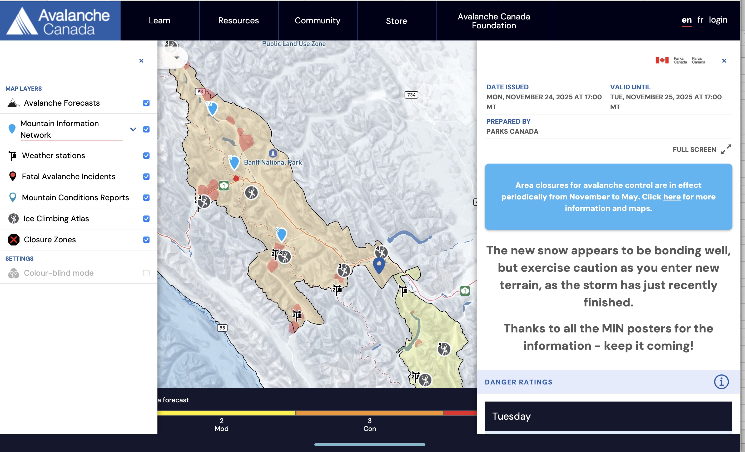
There’s a list of “simple” routes in the Ice and Mixed App, as well as on the Parks Canada page. This page is excellent information in its own right for anyone coming climbing here. . The list for Kananaskis Country is currently unavailable.  If you start with avalanche danger then route selection is much simpler, and safer. At the beginning of every season I start reading the avalanche bulletinss on avalanche.ca. I read them every single day for Kananaskis, Banff Park, Little Yoho (Field), and Jasper National Parks. If you read them as the season develops you’ll also develop a sense of what the problems are, and how the local professional forecasters look at the snowpack.
  But there is a lot more information on Avalanche.ca. In the upper left corner there’s a drop-down menu bar with three other critical pieces of information: The Mountain Information Network (MIN), real-time weather stations and a “mountain forecast.” The MIN is an collection of user-generated reports, and you can sub-sort them by type. I look at both the ski and ice climbing reports (how cool is it to have that feature!), and if you look on the map each report has a blue label around it. Often there are reports for the more popular areas, but I look at all of them. If skiers are reporting afternoon class 2 slides on features below treeline then that is excellent information! The Av Can weather stations are an often-overlooked resource. See the screenshot, but each little mini weather station logo has a variety of information. For Field I check the Bosworth stations, for the Parkway the Parker’s Ridge Station, etc. These are vital because they tell you how much it has snowed recently, and how windy it has been, trends, etc. If it’s snowed more than a few centimetres or it’s windy above about 20 kmh then there are likely to be wind slabs growing, bad. The forecasts may lag this information by a lot–the stations are real time. As noted in the Guide’s report on the Masseys fatal avalanche two years ago, these stations can be useful for monitoring winds/snow in real time. High winds and snow are just a bad combination in the Rockies, especially if you’re an ice climber under slabs that are forming rapidly over your head. If you’re low in the valley it can be really hard to see what’s happening at the ridge top level. Somewhere around half the alpine/ice climbing accidents are natural slides from above, not triggered by the climbers, so you’ve got to think defensively at all times. The Ice and Mixed App has the Avalanche Terrain Exposure Scale for 99 percent of the climbs in the Canadian Rockies, as well as suggestions on where to go in higher avalanche conditions. Let’s say the hazard is “Considerable” in most areas at all elevations, and there’s a storm coming in. I’m going to be thinking about climbing in Simple terrain at most, and what roads are going to close so I can get home in the evening, and will definitely NOT be out in bigger terrain. Even if the forecast is “Low” everywhere you’re still using your judgement, “Low” does not mean give ‘er here. But Low/Moderate is a, “Yeah, I’ll research bigger terrain, what types of hazards, terrain.” “Considerable” and above has me on the low hazard, low exposure routes. “High” generally means Haffner or other “never seen a slide there” terrain, or maybe going skiing at the hill, it’ll be good! If you do the above then you’ll have a handle on the biggest hazard ice climbers face, and can choose your terrain appropriately. Often the forecast for the Parkway is quite different than for Kananaskis, don’t be afraid to drive, we do a lot of that here. If I have doubts then I start scaling it back. Note that if you have specific questions or concerns you can call Banff Park Dispatch or Jasper or K-Country and ask to speak to a “Visitor Safety Specialist.” Don’t do this if you’re going to a very common route with low avalanche hazard, but if you have concerns about a bigger route or something obscure, then don’t be afraid to call them up. Please be organized and succinct with your question as they are busy, but they like talking snow and hazard, good people we’re lucky to have. Also check the “General South BC forecast.” Very useful. And the “Backcountry Resources,” more great info!
Public Weather Forecasts: How cold is it going to be, any big storms forecast, sun? If it’s below about -15, maybe -17, I don’t go multi pitch climbing. It’s miserable, and if there is an accident the temps could turn a broken ankle into a fatality. Go run laps in a single pitch area, stay warm, have fun. If it’s March and sunny then sun–effected slopes are going to be an issue. In January it’s probably where you’ll want to be on a cold day. It’s often warmer just over the continental divide (Haffner, Field, Radium, Golden) than it is to the east of the divide, check out the public forecasts.
Research, Social Media I then hit social media for reports on what has been climbed and not. Facebook is about the best place for this right now, and there are two groups: Rockies Ice and Mixed Conditions is straight up conditions reports, usually pretty solid. Canadian Rockies Ice Climbing is more random, and you may get some insight into local drama, but there’s a good thread on Ghost Road Conditions (very relevant) and often some decent info. Scroll back through both, there’s a wealth of information there. One resource that’s often overlooked is the ACMG Mountain Conditions Report. These are reports submitted by guides, so generally solid. A lot of ski conditions, but also ice info. The “Regional Summary” is also very useful, I check it all year for alpine climbing etc.
Research Access, Descent, etc. There unfortunately isn’t a good guidebook to the Rockies in print. But there is an App, which has every route in the Joe Josephon’s out of print Waterfall Ice guidebook, all the routes from Sean Isaac’s Mixed Guidebook, and 99.99 percent of all the new routes done since then. It also has GPS parking and route locations for about 750 of the 1500 routes in the book, and GPS traces for several hundred. It will save you a LOT of time. Please consider sending in a trace if you do a route that doesn’t have one, thanks! It’s continually updated. Mountain project also has good info, and of course search the internet, a LOT out there. If you’re looking for a paper guide Brent Peter’s nice “Ice Lines” has some classics. Terrain Angle in Mapping Apps/tools. Many now have shading for slope angle, which can tell you a lot about the snow collection area and slide potential above a route. CalTopo is currently my favourite, but also available in FatMap etc. I like to do a route plan, with rough times on it, descent notes, (number of raps, station location), times for various points, alternatives in the area in case people are on “my” route, etc. This just helps me stay organized, and think ahead. Grades are really arbitrary, but the big idea is to climb something you’ll enjoy, and not whip from. I’ve written lots on why falling on ice sucks, enough already, but try to choose something that seems like you can enjoy it. Or go toproping and enjoy that, yeah! I generally try to under-call the day a little bit so I have a margin in case something goes wrong. It’s much more fun to be back in the bar saying, “Yeah, we sent that, could have done another one!” than, “Shit, it’s dark, let’s snuggle while we wait for light…” I could write a book on all the rest of the pre-trip planning stuff, but this is getting long already so let’s keep moving… Pull specific Spot WX forecast This looks confusing, but spend a few minutes, it’s not as weird as it looks, and it has far more information than the public forecast. I like the GEM LAM forecast generally, but find one you like ha ha :). The precipitation line is VERY useful, same with wind direction, temp, just great. With the above you’ll have a decent idea of what’s going on, and can start scheming. If a route is posted on Social Media then it’s likely going to get mauled, so I more use it for thinking, “OK, X and Y are in, both north facing at 2000M so that’s a good zone to look in, Z and A are south facing and low, not in, avoid those” etc. I may also call friends, or post on social media if I’m trying to figure out what’s going on out there. The better information you have the better decisions you can make.
Avalanche Gear: If there’s enough snow to slide I bring it in the car just in case, you never know where you’re going to end up. Even on climbs such as Whiteman’s (very narrow canyon with small-seeming side chutes coming in) I’ve seen slides big enough to bury someone. So I bring the gear at least in the car and usually to the base if not up the route, and this has become common practice here.
Communications: Cell phones work in Field, most of the Bow Valley (if you can see the road), but not generally in K country, 93 South (Radium parkway), or 93 North (Icefields Parkway). If you break your leg in winter and can’t call for help your odds of dying are really high. Nights are long and cold here. Almost everyone here goes out the door with an InReach satellite coms device both for the SOS function, and to text the boyfriend/dad/whatever that you’re OK but running late so don’t scramble the rescue just yet. These are awesome tools, just get one. Radios used to be the standard before satellite coms, but unless you’re pre-programmed with the repeater frequencies they are near-useless. Just get and bring an InReach.
Road Conditions: Alberta British Columbia And we mostly play by the “ice climber’s responsibility code” up here, good info. Leave a note on your car, don’t climb under other people, that sorta thing. Oh, and you can hire me :). . I’m also happy to recommend other guides if I’m busy, please hit me with an email.
Posted in: Blog
No comments yet... add your voice!
I'm more than happy to hear your thoughts on what I've written. Please note that all comments will be moderated before publishing. Thank you for joining the conversation.


 Step 1: Go To The Avalanche Canada Page